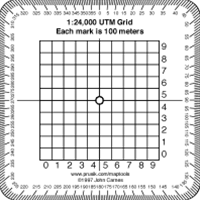
The MapTools 1:24,000 Scale Pocket Size UTM Grid is a handy tool for accurately reading and plotting Universal Transverse Mercator (UTM) coordinates on 1:24,000 scale topographic maps.
Key Features:
- Clear Grid Lines: The grid lines are clearly marked, making it easy to read and plot coordinates.
- Compact Size: The tool is small and lightweight, fitting easily in your pocket or backpack.
- Durable Construction: Made from durable plastic, ensuring long-lasting use.
- Easy to Use: Simply align the tool with the map grid to read the easting and northing values.