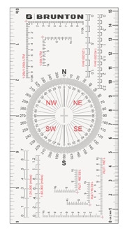
Brunton Map Multi-Tool Card
The Brunton Map Multi-Tool is a compact and versatile tool designed to aid in map reading, navigation, and geological fieldwork. It's a must-have for geologists, hikers, backpackers, and anyone who relies on topographic maps.
Key Features:
- Rulers: Includes both inch and centimeter rulers for accurate measurements.
- Romer Scales: Provides multiple map scales for precise measurements on various maps.
- Unique Protractor: Allows for easy measurement and plotting of angles on maps.
- Strike and Dip Crosshairs: Helps in geological field work for measuring rock formations.
- Durable and Waterproof: Built to withstand outdoor conditions.
- Compact and Lightweight: Easily fits in a pocket or backpack.
Your Dynamic Snippet will be displayed here...
This message is displayed because youy did not provide both a filter and a template to use.
